|
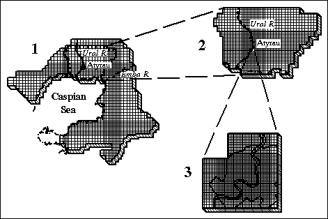
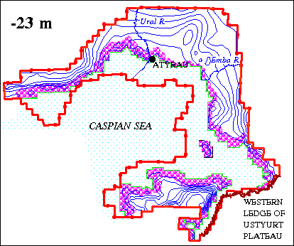
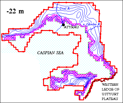
Prediction map of the contour of water table of the
Kazakhstan part of the coast of the Caspian Sea on the period to 2028 (compiled
V.V.Veselov, V.Yu.Panichkin) in note of sea: |
|
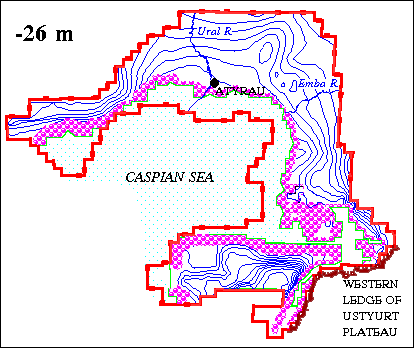
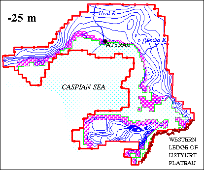
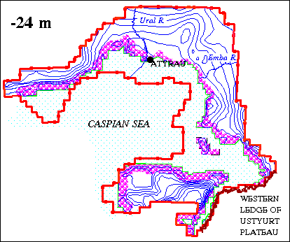
6 variants of the predictions for sea level
elevations –27, -26, -25, -24, -23, -22 m was calculated on the regional model.
Prediction was executed on the term for 30 years. It was assumed that the rise on the
Caspian Sea goes on instantaneously. Compiled prognostic maps of the contour of water
tables was given on Fig. Also the regions of the head of subsurface waters in coastal zone
was given on the maps. Analysis show that an extensive areas will turn out to be under
water as a result of the possible further rise of the Caspian Sea level. Present time
their total area in limits of the modelled region is 14.8 ths. sq. km (for sea elevation
–27 m). For elevation –22 m, it will increase to 37.3 ths. sq. km. Conclusion may be,
if you compare results of the different prediction variants, as a rule, zone width for
head not more 5-10 km. It’s state in plan is determined firstly by prognostic level of
water in the Caspian Sea (by prediction variant) and by relief of the coastal zone. Size
of the prognostic rise of subsoil water level by comparison with it’s state present time
averages mainly not more 30 – 50 cm, and it increase to 1 – 2 m, rarely to 3 – 4 m
only in immediate near from coastal line. This size depends from absolute elevations of
level surface of subsoil waters in the coastal zone for undisturbed conditions. Prognostic
rises of the levels are more for areas with low elevations.
Surge phenomenons play certain role for
creation of the level regime of subsoil waters in coastal part. Duration of the surge,
it’s height, steepness of shore and area of submerged territory, thickness of the
aeration zone and it’s filtration properties influence on volumes of the marine water
coming in water-bearing horizon. Short-term (from 6 to 20 days) rises of the subsoil water
levels was fixed by experimental way, it’s amplitude is 0.1 – 0.4 m. Estimation of the
surge phenomenons influence on subsoil waters was executed also on the model of the Atyrau
city territory /1, 2/. It was believed that surge size in Atyrau is 1.95 m. Duration of
the surge is 5 days. The change of the subsoil waters level was predicted for 3 months
after surge. The decision method was that. For a 5 days water elevation rised on surge
size from –26.84 (1993 year) to –24.89 m. Then the elevation of the water level in the
Ural river returned on previous level. The results of the calculations on 1, 3, 5, 6, 8,
10, 15, 20, 30, 95 days after the beginning of surge was analysed. It was established that
the short-term surges can not give the essential rise of subsoil waters on the territory
of city. They cause drowning a little only for narrow coastal zone on the distance to 100
m from river cut. Practically full return of subsoil waters level to previous state goes
on for a 3 month. In such a way, retaining phenomenons were caused in subsoil waters in
city firstly by self-drowning a little processes at the cost of leakage from water-supply
and sewer net of the city watering of green plantings and filtration from the irrigation
canals.
In conclusion it is necessary point out the
following:
- Executed modeling allowed to estimate
influence of the possible rise of the water level in the Caspian Sea on subsurface waters
of coastal. State of the drowing zone in plan is defined firstly by prediction level of
water in the Caspian Sea and the relief of coastal zone. Width of this zone depends from
hydrogeological conditions of the concrete parts of the coast-filtration and capacity
properties of the water-enclosing rocks, thickness of the water-bearing horizon, of the
stream slope of subsurface waters.
- Definite influence on regime of subsurface
waters of the coastal parts exert also surge effects, it’s role on the some areas may be
very essential.
At a later time it is appropriate creation of
the detailed models of some parts of the coastal territory that have important role for
economy. It is necessary for more authentic estimation and forecasting of the possible
rise of the background water level in the Caspian Sea, and also surge phenomenons on
subsurface waters. |
|
Literature
1. Veselov V.V. Mirlas V.M.,
Panichkin V.Yu. Prediction of the subsoil waters level under the effect of the head from
the side of the Caspian Sea //Book: The Caspian Sea and coastal zone. Almaty:
"Olke", 1995. p.84-90.
2. Veselov V.V., Spivak L.F. The basics of the structured modeling of the
hydrogeosystems.
- Almaty: Gylym, 1997, 216p. |