Veselov V.V., Panichkin V.Yu., Kalmykova N.V., Miroshnichenko O.L. Institute of
Hydrogeology and Hydrophysics of the Ministry of Science and Higher Education of the
Republic of Kazakhstan |
|||
| GEOINFORMATION SYSTEM OF HYDROGEOLOGICAL CONDITIONS OF THE EAST PRIARALIYE | |||
Fig.1.
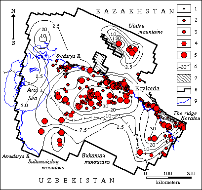
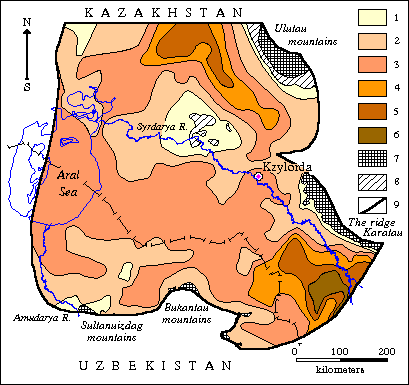
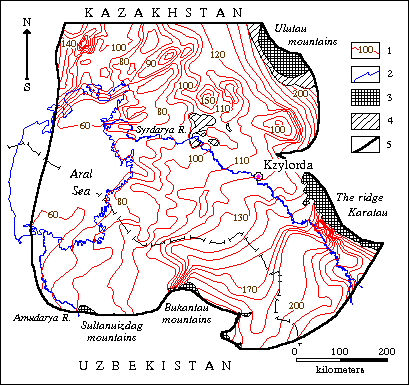
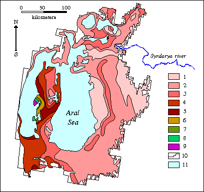
Map of water-conductivity of water-bearing complex of Upper Turon-Senonian sediments Water-conductivity, m2/day: 1 – less 100, 2 – 100-300, 3 – 300-500, 4 – 500-800, 5 – 800-1000, 6 – more 1000; 7 – outcrop of Paleozoic rocks; 8 – areas without water-bearing horizons; 9 – investigation area boundary Fig.2. Map of forecasted lowering of subsoil water level of Upper Fig.3. Map of common thickness of
water-bearing complex of Upper Turon-Senonian sediments Fig.4. Map of hydroisopiestic lines
of Upper Turon-Senonian Fig.5. Map of salt-transportation
modulus of the Aral sea basin as of |
Since 1996 Institute of Hydrogeology and Hydrophysics MS-HE RK conducts works on development of automatized information system (AIS) of East Priaraliye. As is well known, this territory was recognized region of ecological disaster. Deficit of high-quality drinkable water is one of most critical problem. At present time fresh subsurface waters is deep-seated Cretaceous water-bearing horizons are single reliable source of water-supply (look the paper of Veselov V.V., Kasymbekov D.A., Makhmutov T.T., Panichkin V.Yu., Miroshnichenko O.L. "Subsurface waters of Priaraliye and perspectives of them use"). But intensive and without control use can sharply worsen critically unfavourable situation at region. An authenic information is necessary for situation analysis, taking founded decision on rational use of the water resources. Available information is dispersed in different reports, year-books, papers and so on, often is duplicated and distorted, of course it extremely complicate a search of a need data. Therefore it is necessary to develop AIS for East Priaraliye. The basis for developed complex is geoinformation system (GIS), base of primary hydrogeological data and documentographic system. The system of the mathematical modeling is used for choice of optimal ways for exploitation of subsurface water resources, estimation of possible negative consequences for the environment, long-term and efficient forecasting of hydrogeological changes as a result of economic activity. It allow to look developed complex as a version of automized system for support of decisions taking on managing by water-economic activity in the region. Now GIS contains some information about hydrogeological modeling results executed earlier in the Priaraliye (Fig.1). It is model of the Aral Sea basin (Zolotarev V.P., Vinnikova T.N., 1990) and a regional model of the East Priaraliye (Veselov V.V., Panichkin V.Yu. and other, 1991). At present time input of the actual material map was completed. On this map are presented location of the active water intakes, the large subsurface waters deposits with approved reserves, regime and exploration wells. A numbering of the special maps of hydrogeological parameters for scale 1:500000 is begun. It are maps of water-conductivity, coefficients of water-enclosing rocks filtration, absolute marks of level surface of subsurface waters and their mineralization, thickness of a water-bearing horizons and other. Some of such maps was presented on Fig.2-4. At the same time a base of primary hydrogeological data is created (Fig.5). Information on exploration and regime wells, level regime of subsurface waters, their qualitative composition, results of experimental-filtrations works, as well as data on productivity of water intakes. Now information on more than1800 wells is in base. Upper Turon-Senonian water bearing horizon was presented in database most enough. It has important significance for water-supply of population of the Priaraliye. Documentographic system is applied for accumulation and storing of bibliographical descriptions of documents (reports, papers, monographs) on the Aral Sea problem. Further it shall be possible the storing in the system of documents proper (firstly report materials on works executed by Institute of Hydrogeology and Hydrophysics MS and HE). Modeling system is a part of the complex. It was destined for problems decision of long-term and efficient forecasting of hydrogeological changes in the region, optimal managing by regime of exploitation of water intake buildings, conditions investigation of forming of subsurface waters taking into account different natural and artificial factors that influence on it’s state. Information stored in GIS as well as in base of primary data easily can be used for sketching of hydrogeological conditions and formation of mathematical models of concrete district of the Priaraliye. Modeling results is analysed and taken shape by means of GIS. There is possibility for automatized creation maps with hydrogeological parameters with using as primary information data storing in base of primary data. Then this maps may be viewed and edited with the help of GIS. Base of primary hydrogeological data was developed and operated on the basis FoxPro 3.0. MapInfo 4.0 was applied for input, storing and processing of cartographic materials. Bibliographical system of documents descriptions works on Access 2.0. Programme complex for modeling of hydrogeological processes is written on FORTRAN, C and PASCAL. MapBasic 4.0, Surfer 6.0 and AutoCad 14 is also used. Automatized information system of hydrogeological conditions of Priaraliye is operated on complex that contain server and 4 working stations. Institute of Hydrogeology and Hydrophysics seeks the interested partners ready to participate at works financing on further development of geoinformation system of hydrogeological conditions of Priaraliye, replenishment of database for primary hydrogeological materials, perfecting of programmes, method and technology of complex use for decision of problems of rational use of subsurface waters in region. |
||
| Our address: 94, Valikhanov Str. |
|||