Ilan Shakibaev,
Chief ingeneer Jetisy hydrogeological reclamation expedition Ministry of agriculture

AMELIORATION SERVICE UNDER THE MINISTRY OF AGRICULTURE REPUBLIC OF KAZAKHSTAN
The irrigated areas in Kazakhstan occupy the territory of 2.3 million hectares, 1.6 million hectares out of this number are arranged in the southern regions of the country. They are the lands on which over 30% of all crops are cultivated. Kazakhstan, because of the natural and climatic conditions, is the zone of risk farming; thus, irrigation plays a 
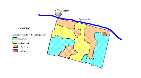
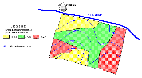
significant role.
The immensity on one side and low quality on the other side of the irrigation systems constructed during the soviet time, transition to the market economy, land privatization, establishment of a new form in the stead of former ownership --all caused the defection of the water management structure, cut down the cultivated areas, caused quality degradation and productivity decline of irrigated lands. The above-mentioned events also "contributed" to the intense salinity processes, erosion, and the worsening of the environmental situation on these territories. In recent years, due to these reasons, south regions have been using only 1.2 million hectares out of the total land irrigation fund, and there is a tendency of the saline lands to increase from 8 to 13 percent.
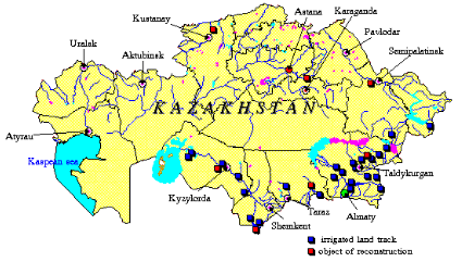
Irrigated land track location scheme The Aral Sea tragedy is directly tied with water diversion from the Syr Darya. Kazakhstan alone takes 6 km3 of water for the irrigation of 777 thousand hectares of lands in South Kazakhstan oblast and Kyzyl Orda oblast. Because of uncontrolled use of water and land resources, during the last score of years the Aral Sea basin turned to the ecological disaster zone. The tense environmental situation on the irrigated lands is being developed also in the basins of Balkhash Lake, the Irtysh and Ili rivers.
kaz_en.gif (25808 bytes)
The governmental control over the status and use of irrigated lands in Kazakhstan, surface and ground water monitoring has been established by the amelioration Service, which contains three regional expeditions: Jetysu (the head expedition), South Kazakhstan and Kyzyl Orda expeditions. The monitoring is used:
  • To study dynamics of ground water levels and salt regime, and assess the irrigated lands status;
  • To study and assess salinization of irrigated lands and soil qualities;
  • To value the chemical composition and quality of irrigated, ground and drainage waters;
  • To appraise the degree of pollution for irrigated, ground and drainage waters.
Salinity of soil of the reconstruction object "Akkum" productive cooperative in Kyzylorda oblast map The Ministry of Agriculture, loaned by the World Bank and the Asian Bank, is running the Projects of Irrigation and Drainage Systems Improvement. The projects intend to make a complete reconstruction of the irrigation system on the area of 70 thousand hectares in all regions of the Republic. Currently, in the Aral Disaster Zone investment and national programs addressed to the infrastructure rehabilitation, including irrigated farming, are being carried out. The World Bank’s loan made possible to start reconstruction works on the area of 1034 hectares in the Production Cooperative Akkum, Zhalagash rayon, and Kyzyl Orda oblast. The Project designs to reconstruct irrigation canals and the drainage collector network, level the lands and rebuild the hydrotechnical facilities. The institutional issues also bulk large, particularly the issues relating to the establishment of private water users’ associations, which will bridge a gap in the niche of water management.
soli_en.gif (12066 bytes)
Groundwater contour and mineralization of the reconstruction object "Akkum" productive cooperative in Kyzylorda oblast map
wate_en.gif (16481 bytes)

These activities alongside with organizatonal and technological measures will ensure the lasting operation of irrigation systems, raise the crop yielding and reduce water consumption by 15-20%.
The similar works will be conducted according to other investment projects. The projects plan to do combined organizational and technical works and execute the ensuing monitoring for all changes, and for the development of preventive and mitigating measures.
The elaboration of a reliable information support for saving, processing and analyzing the data is the important step in the course of the irrigated lands monitoring activities. Ameliorative expeditions arm-in-arm with the Institute of Hydrogeology and Hydrophysics develop, using computer means and software, the Integrated Geoinformation System. As of now, the methodological basis has been prepared to develop the database for the level regimes and chemical composition of the ground water, physical and chemical soil qualities, and the data bank of cartographic materials for the projects subject to reconstruction.