Spivak L.F. |
||
ARCHIVE OF DIGITAL SPACE IMAGES OF THE ARAL SEA |
||
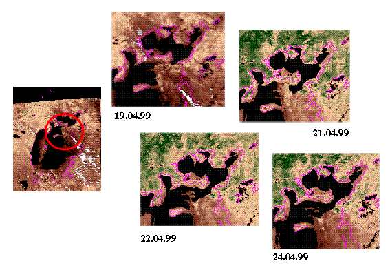
Ecological problems of the Aral region continues to attract attention of the numerous researchers. The contribution to their decision is brought by the scientists of Space Research Institute of the Ministry of science and Higher Education (SRI) also. In particular, within the framework of the program of salt-dusty storm monitoring the regular space survey of coastal zone of the Aral sea are conducted with use of the equipment established on the NOAA (USA), "RESOURCE-О1" satellites and module "PRIRODA" of orbital station "MIR". At the SRI Centre of reception of the space information the primary processing and archiving of the remote sensing data is conducted. The space images allow to receive the important information on seasonal dynamics of a vegetative cover in region, changes of a coastal line, development of deserting processes, origin dusty storm and set of other interesting phenomena. The AVHRR NOAA images are offered to attention of the readers, on which the moment of dam break is fixed. This dam divided northern and southern parts of the sea The break has taken place 21.04.99 and already 22.04.99 both parts have incorporated. It is necessary to note, that the break was preceded by the powerful cyclone, past above the Aral region on April -20. The detailed information about archive of space images of the Aral sea can be received on telephones ( 8 -327-2) 49-28-72, 49-43-55 (fax) E-mail: remote@astel.kz |
||
| Space monitoring of North coast of Aral Sea by NOAA satellite data | ||
 |
||