| Crisis
situation in the Kazakhstan part of Priaralye mainly is caused by shortage of the drinking
water. This problem is most sharp at Kzylorda oblast. The Syrdarya river is main water
artery in region. But last 15 – 20 years it is already not main source for water supply
because pollution by industrial outflows and overflow waters from sewage-farms. More using
of subsurface waters is one of ways for decision of this problem. Subsurface waters are practically in an all lithological and genetic complexes in the region, from Paleozoic to recent sediments. The exploitation reserves of subsurface waters explored for using in Kzylorda oblast are estimated as 1372.7 ths. cubic metres per day including for economic and drinking water supply – 1060.8 ths. cubic metres per day. From them reserves of subsurface waters for Cretaceous complex are 680.6 ths. cubic metres per day (position on 1.1.97). Total water consumption of subsurface waters is about 500 ths. cubic metres per day for oblast including approximately 150 ths. cubic metres per day improvident self-flow of bore-holes, and only 350 ths. cubic metres per day are used mainly for industrial and drinking goals. Need of the oblast in the drinking water is about 531.8 ths. cubic metres per day. This need may be fully satisfied by using of subsurface waters. Intensive economic opening up of the Priaralye extremely negatively told on the condition of environment including subsurface hydrosphere. Non-deep depositing subsoil waters was turned out to be more vulnerable. Presence of nitrates, nitrites, ammonia, ammonium, phenol, increased oxideability are registered in regions with irrigating massives. An influence of technogenic processes on the state of the pressure waters of the Upper Cretaceous that have practically universal distribution and satisfactory quality was reflected in smaller degree. So using them for decision of water-supply problem is considered as well-founded. Present time main water-consumers in Kzylorda oblast are cities Kzylorda, Baikonur, Aralsk, Kazalinsk, 8 settlements and more 380 small rural inhabited localities. Total population in oblast is about 665 ths. man. From them in rural locality live 232.8 ths. man. Water-supply of large cities present time is executed partly at the expense of subsurface waters of explored deposits (Fig. 1) by group water pipes. About 250 rural inhabited localities use for drink goals subsurface waters by means of single bore-holes and wells which water do not corresponds to request of GOST "Drinking water". More 50 inhabited localities are forced to bring out water. Problem of the drinking water-supply for the rest inhabited localities is more sharp. |
|||
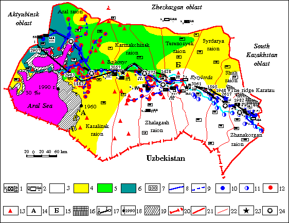
| Fig.1. The plan of the water-supply conditions of inhabited localities by subsurface waters of perspective Upper Cretaceous sediments | |||
 |
|||
| I.
Deposits (parts) of subsurface waters: explored for the economic-drincable water-supply of
inhabited localities: 1 – under operating (on the left of sign-index of geological age of the water-bearing rocks; on the right of: in numerator – approved operating reserves on categories A+B+C; in denominator – actual water-selection; ths. cubic metres/day; 2 – non-operating. II.
Areas of subsurface water distribution of Upper Cretaceous sediments with different III. The lines of main water-pipes
and their distribution netwrks IV. Zones of the ecological disaster
of the Priaralye: established by "The Law of the Republic of Kazakhstan on Social
Defence" dated 30.06.92 N1968 A-XII V. Additional signs Boundaries: |
|||
| Still
1991 Institute Kazgiprovodhoz proposed "Plan of the development of the agricultural
water-supply of Kzylorda oblast" which include some alternative variants:
centralized, non-centralized (local) water-supply with using and without using distiller
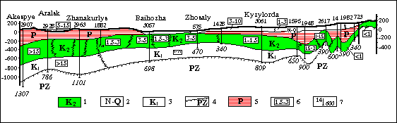
installations and other. Later, 1996 "Programme for radical improvement of conditions of industrial and drinking water-supply of rural inhabited localities in Kzylorda oblast" was developed by the specialists of the Ministry of Geology and Protection of Underground Resources of the RK. It’s authors proposed an economically more beneficial variant that include centralized water-supply only large consumers at the cost of an exploitation explored deposits of subsurface waters by completion of construction of grope water-pipes – Aral-Syrdarya and Kzylorda Right-bank. Organization of the local water intakes equipped by distiller installations for exploitation of low-mineralized waters of Upper Turon and Cenonian complexes near consumers was offered for water-supply the rest of inhabited localities (Fig. 1, 2). |
|||
Fig.2. Schematic hydrogeological section on I–I line |
|||
 |
|||
| 1 –
water-bearing complex of Upper Cretaceous sediments (perspective); 2 - water-bearing complex of Neogene-Quaternary sediments (subsurface waters with heightened mineralization or non-protected from pollution); 3 - water-bearing complex of Upper Cretaceous sediments (less perspective); 4 – sedimens of the Paleozoic foundation (practically arid0; 5 – water-resisting sediments of Paleogee; 6 – mineralization of subsurface waters, g/cub.dm; 7 – borehole: above – number, below – depth, m |
|||
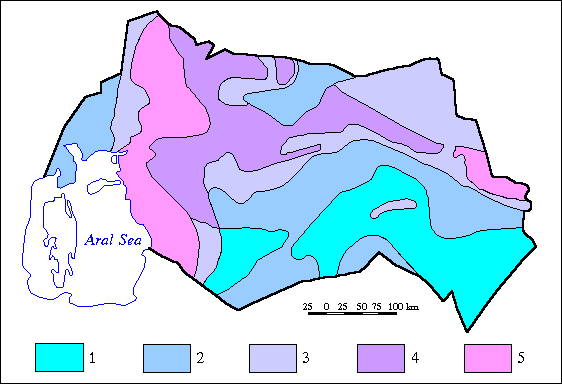
| Heterogeneity and irregularity of distribution on area of subsurface waters resources, water intakes productivity, also mineralization of subsurface waters must be take into account deciding water-supply problem of Priaralye at the cost of subsurface waters. Outline of the zoning that executed on these sings, is given on Fig. 3. | |||
| Fig. 3. Provision of the Priaralye by subsurface waters | |||
 |
|||
| Priaralye’s
territiries provided by forecasted resources of subsurface waters mainly: 1 – for water-supply of large water-users and irrigation of lands, boreholes expenses from 20-50 l/s for mineralization of water from 1 to 3 and to 1 g/l; 2 – for water-supply of middle user and irrigation of lands, boreholes expenses to 20 l/s for mineralization from 1 to 3 g/l; 3 – for water-supply of small users and irrigation of lands, boreholes expenses to 5 10 l/s, rarely 20 l/s, waters mineralization to 3 g/l; 4 - for water-supply of small users and irrigation of pastures, boreholes expenses from 1 to 10 i/s rarely 10–20 l/s, water mineralization from 1-3 to 3-5 g/l; 5 – areas with mineralization of subsurface waters more 5 g/l. |
|||
By this means, water-supply improvement for Priaralye population at the cost more full use of subsurface waters is quite possible. Mathematical modeling of the Priaralye hydrogeological conditions is necessary for improvement of basing of decisions on use of the subsurface water resources. It will allow to choise more optimal variant, predict possible the negative consequences of technogenic influence on environment and opportunely develop measures to minimize them. |